Blog
Muddy MTB
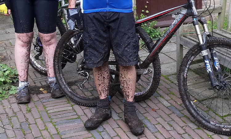
Anyone would think it had been raining...
Hot!
Yesterday it was 34 degrees C (94 deg F) in Wageningen. This morning it was not quite so hot, about 26 degrees, but it still felt very warm when cycling hard; just look how hot my daughter looks in the photo. It also meant that some of the sandy patches were very loose and treacherous. The advantage was that, just like when it rains a bit, the woods were a lot emptier than you might expect for the time of year. And we saw a red squirrel, which is always nice.

Tour de Yorkshire
Ok, this is neither mountain bikes nor Wageningen, but Cavendish is not the only one with a mother in Harrogate

The Hell of Ede-Wageningen
Last Saturday it was the annual Jan Janssen Classic here in Wageningen, which for those of us who prefer to ride off-road means the 'Hell of Ede-Wageningen'. As usual there was a choice for 50 or 95 km, and as usual I did the 50. It was great, perfect weather, super organisation and a wonderful atmosphere. About 5000 cyclists turned up, of which 600 mountain bikers, which meant that more than normal of those who had signed up (and paid!) in advance did not come. No one knows why, especially seeing the weather was perfect. Unfortunately parts of the route was not quite as nice as last year as the Gelderse Landschap and Ministry of Defence (landowners) were less cooperative than in previous years. But that was only a minor detail in what was a great ride.

"Playful King of the Mountains"
Ever Spring we are lucky enough to spend a week in the North Eifel, which is an area of Germany that has a number of things to recommend it , including that it is hilly, it is full of orchids and it is only 2 1/2 hours drive from Wageningen. I have written before about Andreas Meyer and Tobias Mommer's excellent book of mountain bike routes in the area. Route number eight in the book is called 'Verspielte Bergwertung', which you could translate as 'Playful King of the Mountains". They give the route four out of five points for both technique and condition, but is coded red (not the more demanding black), so I was curious to see how difficult it would be. Although 'only' 30 km long, it does have almost a thousand meters of climb, which makes 30 km quite enough. The route was cleverly chosen so that the long, steep uphills were mostly on tarmac and the downhills were virtually without exception wonderful singletracks through some really beautiful woodland.
 Normally I'm not so keen on tarmac, but in this case it did make going up the long hills more practical. At least it was not as bad as taking the ski lift. I noticed that there were some parallel tracks to the road, so probably if you wanted, you could manage to do some of the uphills off road as well. For instance the photo below was taken after a long (albeit beautiful) pull up on a road (to the left), but there was also a track running up the other side of the valley. I guess that was one of their criterion for making it a red route.

At the top of the hill there were some quite spectacular views (mostly, sometimes you were in the woods, so no views to be seen). Of course, the knowledge that you have cycled over the hills in the distance makes them even more spectacular!

At the bottom of the hills you come out of the typical flat-bottomed valleys of the Eifel. The rivers have cut through the soft chalk, leaving a plateau at the top, steep side (unsuitable for agriculture, so covered in trees) and the farmland at the bottom. Fortunately, this is mostly not too intensive, but either wildflower meadows, or at least grassland filled with dandelions, buttercups and sometimes oxlips.

The nature of the landscape means that you can virtually guarantee that here will be some quite challenging downhill slopes. The photo below shows one that would have been quite impossible if I had not put my saddle right down. As you can clearly see, it was very wet and slippery. What you cannot see so well (a bit if you look hard at the top of the photo), is that parts of it were incredibly steep, so that only by hanging right over the back of the saddle (or by putting it right down), could you possibly hope to get down without tumbling over the handlebars. And at the bottom, Veronica beccabunga, a lovely chalk-stream flower (albeit not yet flowering). What more could you want?

Route planner
The Dutch cyclists' union ('fietsersbond') has created a brilliant route planner which has detailed information about all the cycle paths in the Netherlands, including data such as the surface type, if it is in nature and if it is away from cars.
This is now also as an embedable app, and so also available from my own website, or you can go to the original site.