Blog
The woodpeckers are back

Yesterday, for the first time this year, a woodpecker came into our garden, searching for food. They have come every year for the past few years now, usually first the adults and then later when the chicks are fledged, the adults bring the juveniles along as well. So when we headed off into the woods on our mountain bikes this morning, I was wondering if we would see any there and, sure enough, every few minutes we heard the rapid hammer-action of a woodpecker beak smashing into a tree, looking for insects to eat or even starting on a nest. Whilst pausing for a rest in the Bennekomsebos, after a particularly slippery and muddy stretch, one flew onto a branch on a tree right next so the path, so that we could take a good look at it.
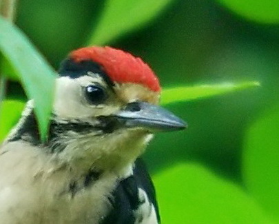
I took the photo on the right in my garden a couple of years ago. You can see from the big red blob on top of the head that it is a juvenile. The adult male has a red neck (and no red hat), which the female lacks. The Great Spotted has red under its tail which (together with the size) distinguishes it from the other species you can find here.
Do not try this at home
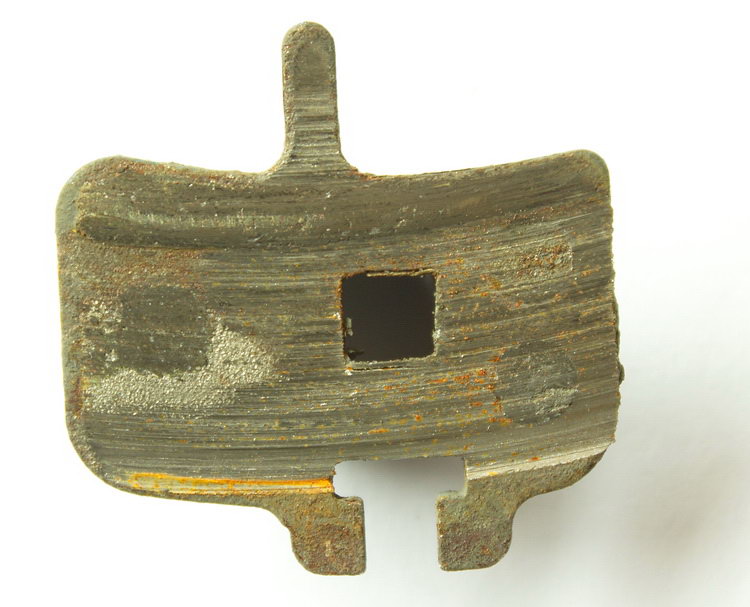
Last time I was out I noticed the brake making a bit a scraping noise, and sure enough there was absolutely no pad left at all on it when I extracted it. The sandy soil round here is very punishing to parts like this; if it is a bit wet (snow included), the sand and water form a very efficient scrubbing mechanism, which can cause wear at an astonishing rate. Of course it is a good idea if you spot this happening a little before there is zero pad left, but amazingly even in this state there was still a remarkable amount of stopping power left, although naturally it was not all too good for the health of the disks. Hopefully the new pads will be able to polish them smooth again!

Roel's new shop is open!
Roel Peerenboom has moved from his old shop on the Churchillweg to newly refurbished premises in the city centre. Today was the first day that it was open. Even though everything is not quite in its final place yet, it is still looking very impressive. A great improvement on the old place. Good luck with your new shop Roel and Cindy!

See the Shops tab for location, etc.
Deer in the woods
One of the good things about mountain biking in the snow is that you stand a better chance of seeing some wildlife. The snow quietens everything down, so you don't scare them off from such a distance. If it is still snowing, like it was today, that scares the people off, so that also helps. And so today, we saw two deer, reasonably close, and when we stopped, they just moved a small distance and stood and watched us, as we stood and watched them for a while. In addition to the actual animals, there are all sorts of interesting tracks on the ground. Today we saw quite a lot of what I think was pheasant tracks. There is a long narrow sweeping line, caused by the long tail feathers trailing in the snow as they walk around. It is so narrow and straight that it looks quite unnatural, like a child has been making stripes in the snow.

Winter wonderland

Yesterday afternoon and last night about 5 cm of snow fell, coating everything in a thick blanket of stunning beauty. It was not deep enough to be really difficult to cycle through (so long as you watch out for hidden branches etc) but seeing there was little wind, all the branches were coated in white. The only thing was that it was so spectacular that all of Wageningen was out in the woods and I passed more dogs, other bikers, walkers, etc this morning than I normally do in a month. I had to try quite hard to find some paths going through unspoilt snow fields with only a few rabbit tracks blemishing the even surface.

Paradise regained*
It has been six weeks since I was last on the mountain bike.  I had to recover from a small operation and am only now fit enough to go off road. As I set off the weather was a bit miserable (below freezing, sleet and snow), but before long I was warmed up enough so that the same conditions changed into not so cold and hardly any snow, with the usual added benefit of this sort of weather that most people hide indoors leaving the woods alone. The thin layer of fresh snow soon smudged out the footsteps, paw-prints and tyre tracks, making it look even prettier. Six weeks of little exercise has of course left me pretty unfit, so I trundled around one our my summer evening favourate routes in twenty minutes longer than the usual hour. Of course, cycling through snow, even if not so so deep slows you down as well. Doubtless what is left of my muscles will be complaining like mad late on. But all that did not matter, I was back on the bike and back in the woods!
(*Note for Dutch readers, the title is a famous poem).
